Only marine navigation app to have route assistance with Voice Prompts for marine navigation.
* Voice Prompts for marine navigation / nautical naviagtion (requires GPS )
-prompts when approaching a boating route marker
-Continous distance and ETA updates
-Alerts when sailing/boating off route
-Alerts when boating in wrong direction
*** For any question, contact support at gpsnauticalcharts.com / http://www.gpsnauticalcharts.com ***
*Route Editing/Creation
-Create routes from scratch
-Edit existing GPX/KML routes.
-Add custom description to any route point.
-Drop markers along route.
► Advanced NMEA Instrumentation
√AIS over TCP/UDP
√Wind speed, direction, temperature, depth, GPS over NMEA
* Offline charts
-Charts reprojected for WGS84 datum.
*Seamless chart quilting of marine charts
*Distance Bearing tool
*Create custom way points
- Using GPS
-Select point on map
-Manually enter latitude & longitude coordinates
*POI layer for marine charts
- Overlay POIs
- POI list derived from the equivalent ENC and contains all categories including Buoy, Light, Harbour facility, Obstr.
*Search POIs/Way points
*Pan/Zoom/My Location
* Record Marine GPS tracks
* View tracks overlay
* Live track animation
* Track analytics/stats
* Export GPX trcks.
-Export to SDCard
-Share GPX trakcs with friends/View on Google earth.
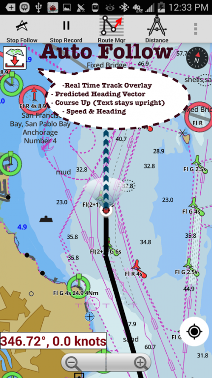
* Auto Follow Mode (Course up)
-Continuously updates boat's location on chart
- Adjustable update frequency
Sample Nautical Charts (please visit http://gpsnauticalcharts.com/main/folio-catalog-nautical-charts-app for complete list)
*Austria - Donau
*Belgium - Rupel, Netekanaal, Ringvaart om Gent, Schelde-Rijnverbinding, Dijle, Kanaal naar Charleroi, Beneden Zeeschelde, Bocholt-Herentals, Gent-Terneuzen, van Zeebrugge Achterhaven-inclusief het Boudewijnkanaal-tot en met haven Brugge, Zuid-Willemsvaart, Antwerpen Haven, Moervaart, Beneden-Nete, Dessel-Kwaadmechelen, Estuaire Vaart van Zeebrugge tot aan de Nederlandse Grens, Leie, Oostende Plassendalekanaal, Boven-Schelde, Vlaanderen, Zeekanaal, Albertkanaal, Oostende Haven met de 5-mijlszone Estuaire Vaart, Zeeschelde,
*Bulgaria
*Switzerland - Rhine
*Czech Republic - Roudnice nad Labem, Kly, Lovosice, Libotenice, Kostelec nad Labem, Melnik, Hraz Slapske prehrady, Praha - Holesovice, Steti, Libcice nad Vltavou, Praha - Modrany, Podebrady, Usti nad Labem, Veltruby, Melnik - soutok, Vrane nad Vltavou, Chvaletice, Vranany, Hradistko, Dolni Zleb, Neratovice, Celakovice, Statni hranice CR - SRN, Nymburk, Brna nad Labem, Brandys nad Labem, Kralupy nad Vltavou, Litomerice, Hradistko, Male Brezno, Roztoky, Kolin, Decin,
*Germany - Elbe, Westoder, Ruhr, Rhein-Herne-Kanal, Untere Havel-Wasserstraße (Spandau - Plaue), Weser, Neckar, Berlin-Spandauer-Schifffahrtskanal, Donau, Rhein, Spree-Oder-Wasserstraße, Havel-Oder-Wasserstraße, Main-Donau-Kanal, Wesel-Datteln-Kanal, Elbe-Havel-Kanal, Dortmund-Ems-Kanal, Elbe-Seitenkanal, Mittellandkanal, Mosel, Main, Saar
*France - GRANDE SAONE, MOSELLE CANALISEE, LIAISON DUNKERQUE ESCAUT, GARONNE
*Croatia - DRAVA, DANUBE, SAVA
*Hungary - Danube
*Netherlands
*Romania - Maritime Danube, Sulina Channel, Danube Black Sea Channel
*Serbia - Danube, Sava, Tisa
*Slovakia - Dunaja / Danube
We do not host Europe Inland Rivers-Waterways on our servers. We did not scan it for viruses, adware, spyware or other type of malware. This app is hosted by Google and passed their terms and conditions to be listed there. We recommend caution when installing it.
The Google Play link for Europe Inland Rivers-Waterways is provided to you by apps112.com without any warranties, representations or guarantees of any kind, so access it at your own risk.
If you have questions regarding this particular app contact the publisher directly. For questions about the functionalities of apps112.com contact us.

|
| ||||
| Downloads: 9 | ||||
| Updated At: 2024-04-19 21:07:24 | ||||
| Publisher: Gps Nautical Charts | ||||
| Operating System: Android | ||||
| License Type: Free Trial |